A Place in the Lakes 25th May 2015 (Place Fell, Angletarn Pikes, Beda Fell)

Managed to start this walk at 10.00 a.m. Not as early as I’d hoped. I parked in Martindale which is a quiet little hamlet. There are some fun hairpin bends before you reach it. It has a new (1880) church dedicated to St. Peter and a much older one looking a bit sad dedicated to St. Martin (1500s).

I got up onto Place Fell quite quickly but then it took me a couple of hours to reach the summit. The fabulous views that Wainwright had promised were caught in the low clouds for most of the morning. Also an occasional sprinkle of rain to accompany them.

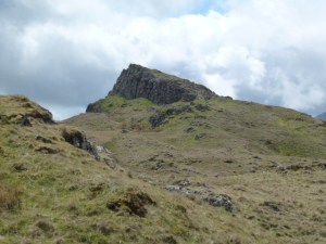
It was then down 250m to reach Boredale Hause which is a big mountain pass/col. From there I went up again for 150m to reach Angletarn Pikes. I ascended the north pike which Wainwright said could only be reached by a rock scramble. Not so, I just walked up a steep grassy bit and then was on a short easy path. Where Place Fell had seemed a bit busy (it was a bank holiday), I had the summit of Angletarn to myself. There are 2 pikes but I only climbed the north one.

I lunched in peace in the sun behind some rocks in a shallow depression. The rocks not me. Two cyclists came along but left me in peace.

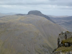
Then it was time to head back along the ridge to Beda Head which is the top point of Beda Fell. It had cleared up weather wise and I got great views across to the huge long ridge which culminates in Hight Street to the east and to the west, Helvellyn and Sheffield Pike. I could trace the route Chris and I took for Sheffield Pike in November 2013. Also another horseshoe I did from Brothers Water.

I’m planning my own longish distance path along the route of the Roman Road between Penrith and Ravenglass. We’ll see! More realistically I could walk from Pooley Bridge up onto the far north end of High Street (not the summit end), taking in several summits but all along the very long ridge which is the Roman Road and ending up at High Street summit, this would be about 14 km. Then to get down to the Kirkstone Pass to meet a bus. Again, we’ll see, I would need to be in Pooley Bridge the night before for an early start.

After Beda Head, I turned east and down to get to the road and then a quick hop past the old church to get back to the car at 16.30. I saw a sign saying that Martindale is home to an old herd of red deer. Didn’t see any.

Managed to get home by 19.15 including a very quick pitstop at Tebay services.

St. Martin's church
St. Martin’s church
Very superior signpost!
The walk to come
The walk to come
Brothers Water
Brothers Water
Helvellyn
Helvellyn
Angletarn Pikes (north pike)
Sheffield Pike
Sheffield Pike
High Street in background
Beda Fell
Beda Fell
Ullswater
Ullswater
Looking back at Place Fell horseshoe
Ullswater
Ullswater
Please visit Map and Compass and learn how to interpret a map and use a compass with me and my navigation partner, Cath.

MAPandCOMPASS

Yewbarrow and Red Pike, 4th May 2015

Pillar continues to elude me, in that I’m not yet ready for it, or at least I have to reconsider how to get to the west side of the Lake District, do big, long walks and get home. The answer is not to try to do it all in one day. I spent as long driving the car as I did up the hill.

So despite getting up at 6 a.m. I didn’t start walking until 10.35 from the National Trust car park at Overbeck on Wast Water. I’d stopped for a very express espresso at Lancaster services and once to send a text. As I put my boots on the lace broke but I had the emergency laces to hand (probably the most essential of the emergency kit). My original plan had been to walk the Mosedale horseshoe which is a very big walk and so I cut it back to climb Yewbarrow and then decide how much further to go. I chatted to a Dutch family in the car park. They had 2 small children and it was their first ever mountain.

The climb up Yewbarrow is quite stiff and quickly reaches scrambling territory. I had to think out my moves but at least with scrambling you get to cover a lot of height quite quickly. I met up with the Dutch family at the top of the gully and they had wisely (the children were only about 5 or 6) decided to retrace their steps. They seemed to have had quite an adventure. It took me 2 hours to get to the top of Yewbarrow. I then whizzed along the top ridge and scrambled down to Dore Head and stopped for lunch on the col.

I decided to climb Red Pike as it seemed a straightforward climb and would notch up another Wainwright. And it was and it did. On the descent there appeared to be a rescue taking place on the side of Great Gable, the Sea King helicopter spent a lot of time going back and forth and eventually went away without apparently having rescued anyone. A rescue did take place, see Wasdale MR for more info.

Back down the valley along a wet path on the western flank of Yewbarrow and down to the car. And then 3 hours and 20 minutes to get home.

Pillar still on the To Do list!

Apart from the first one, photos are in reverse order.

Yewbarrow looking very pointy
U shaped valley along Over Beck
And with Herdwicks
And with Herdwicks
Great Gable looking very mysterious
Pillar and companions in the background
Such poise
Such poise
Stirrup Crag on Yewbarrow's north end
Stirrup Crag on Yewbarrow’s north end
Dore Head col looking to Red Pike
Yewbarrow ridge to Stirrup Crag
Great Door (and so it is)
Wast Water
Wast Water


Please visit Map and Compass and learn how to interpret a map and use a compass with me and my navigation partner, Cath.

MAPandCOMPASS

css.php