This trip had been a long time coming. In 2010 Chris and I had a Lakeland Adventure around Ennerdale Water where we wild camped then stayed in Ennerdale YH and finished up in the Castle Inn on Bassenthwaite Lake for a proper treat. We discussed climbing Pillar and how we would do it.
In 2014, we returned to Ennerdale and walked to Black Sail YH and then Chris got sick. It was very sudden and very clear that we were not going to climb Pillar that day. So we changed our plans and did some other things. She was such a tough woman that she did go up Catbells the next day albeit very very slowly but she was so determined to do it. That was the last mountain she climbed.
I went to Wasdale in 2015 and tried to ascend from the other side. I hadn’t allowed enough time and my boot lace disintegrated and although I had a good walk that day, Pillar was just a stretch too far.
Easter 2018: I booked a break on Derwent Water. I set it up so that I had a choice of 3 possible days to walk and I would just take the best of the 3 from the weather forecasts. The first day had very limited visibility on the tops, day 2 was looking good and day 3 looking very pants. I opted for the Sunday.
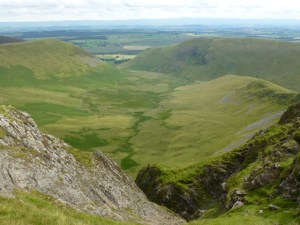
I drove round from Portinscale where I was staying to Wasdale Head, an hour’s drive. Parked up with no problems near the campsite. And then just walked. You have to go quite a long way in what feels like and is completely the wrong direction but that’s so as to avoid things like the screes. So it’s up to the Black Sail Pass and then basically back along and up and up, including a sort of knarly, knobbly knot which was hands on and fun. It’s a good long walk and always another bit to do but after 3 hours I got to the top and just the top plateau was snow covered, I knew it was a plateau but with the name Pillar you are expecting something else! There is Pillar Rock which is a climbing challenge and why the place is called Pillar. Fantastic 360 views of the sea, Ennerdale Water and Sellafield!
The last of Chris’s ashes are now scattered on the top of the mountain she didn’t reach in life.
I had planned to do a circuit but it looked a lot more snowy ahead so I returned via the same route because I was on my own.
Derwent WaterDerwent WaterPillarEnnerdale Water from Pillar
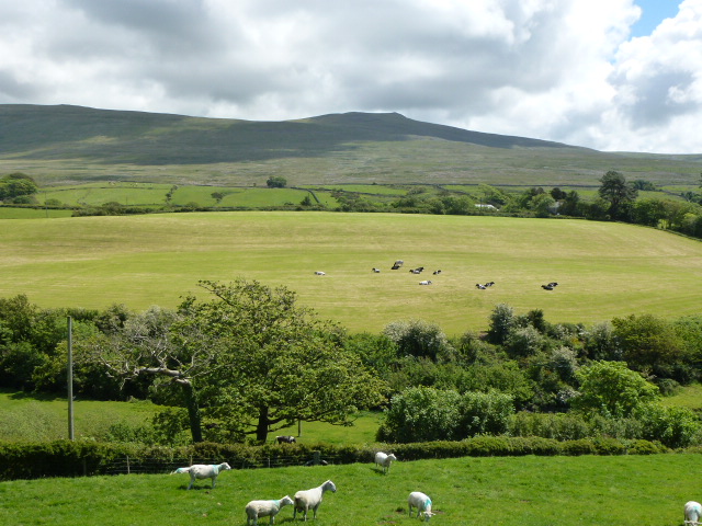
It was very much still winter on this Wainwright fell. I started from Ashness Bridge and plodded my way up the side of Ashness Gill. It was cold but I was able to see for the first half of the ascent and then visibility went down to about 10m. I got to the top of the fell where it was less than that!
Back down and it was nice to come out of the cloud and snow and to look across to where I was staying at Derwent Bank on Derwent Water. A good warm up walk to get me back in the swing of it.
I stayed in an HF Holidays house, it’s the UK’s only cooperative holiday company and it was excellent. So good that I became a member after one night, the room was good and the food was great.
Derwent Water from Derwent BankDerwent WaterDerwent WaterSummit of High Seat
Please visit Map and Compass and learn how to interpret a map and use a compass with me and my navigation partner, Cath.
Today’s walk plan was to knock off some Wainwrights at the back of Blencathra.
I parked up in Mungrisdale on the road verge after an easy journey of 2.5 hours without stopping for coffee. Set off at 10 a.m. Pleasant and easy walk to the top of the crags along a wide path. It was dry but blowy at the top.
From Bannerdale Crags looking back to Mungrisdale village and beyondHeading up to Bannerdale Crags
Down a little to a col which joins the Crags with a spur off Blencathra. At this point I veered off and headed due west to Mungrisdale Common. Wainwright must have been having a joke here, his description starts off with “To add to its other failings …..”, continues with “has no more pretension to elegance than a pudding that has been sat on” and “There is little on these extensive grass slopes to provide even a passing interest for an ordinary walker, and nothing at all to encourage a visit.” So why the bloody hell did he bother to put it in, it’s not even a summit as such. There is a suggestion that it was put in to provide some filler for the book on the Northern Fells. The common is a large, flat stretch of featureless bog. And very tedious because the bog got boggier and boggier as I went along, reminiscent of the bogs on the Isle of Jura. It started to rain so once I’d been and found the “summit”, I squelched my way back stopping for lunch on the way after I’d got off the bog. Not a soul in sight on the common.
I’m on a road to nowhereA helpful navigational aid, just where it needed to be
Back at the col, I went down the River Glendaramackin to reach a footbridge. Over this and then quickly up onto Souther Fell. The rain was coming in fast over Blencathra by this time. There was a path marked on the map which would take me directly to my car so I aimed off but crossed it without noticing (probably because too faint). So I headed back up a little (I’d overshot the distance) and then located the path in the bracken.
Blencathra disappearingWhy it’s called Sharp EdgeTop of Glenderamackin River
This now brings my total of Wainwrights to 74 which is properly over one third of them done. Five and a half hours of walking. Home by 6 p.m.
Please visit Map and Compass and learn how to interpret a map and use a compass with me and my navigation partner, Cath.
Friday 19th June
After I’d done half a day of work and Carol simultaneously had done dialysis, we set off for the Duddon Valley and arrived at our designated parking spot in gloomy grey weather but not actually raining.
We walked the half mile to Devoke Water and found that a large school party had already taken up camping residence ahead of us. We hadn’t anticipated this so we retreated around the corner from them and set up below a small rocky hill but still overlooking the lake.
Just as we were getting settled and comfortable the first bunch of teenagers ascended the hill and larked about noisily for ages. They eventually descended and we breathed a sigh of relief. So much for a quiet wild camp to relax in. I cooked up our dinner in my Jetboil (excellent fast cooker), we had chilli con carne and rice.
Then the next bunch of noisy teenagers went up the hill. This was too much so Carol went and asked their minders to deal with them which they did, they actually went down as Carol went off to remonstrance. However this was all a bit stressful and not what either of us wanted. The noise was carrying very clearly as it was a still evening. The first time I went to Devoke Water as a reccy for wild camping, it was lashing down, the second time we both checked it out and it was blowing a gale so very noisy on both those occasions.
At last we were able to get snug in the tent, I drank a mini flask of rum.
Neither of us slept very well, C kept sliding down the tent, she also had restless legs. Not a good mixture! It rained on and off most of the night.
Devoke WaterSouthern fells
Saturday 20th June
We got up, brewed up (one tea, one filter coffee) and packed up during an interval without rain. Back at the car we drove away from the teachers and parked up on the moor near some large black cows. I made porridge for Carol (instant pot) and brewed up some more hot drinks. Carol has now decided that perhaps wild camping and rotten kidneys don’t really go together so well. However this means that I have to become brave enough to do it on my own, we’ll see…
Into Broughton in Furness to look at the Clocktower Gallery, the bakery and the greengrocers (sells bunches of wild mushrooms, fresh figs and fresh herbs). The rain had just about stopped.
We drove a short distance along the A595 to Broadgate where we parked up. Then a nice trot up a quiet lane to Sunkenkirk stone circle also known as Swinside. We had a picnic on the way in the warm sun, lovely. The stone circle is fairly intact but only accessible on foot as it’s on permitted land on Swinside farm, thus very few visitors. We were the only ones there and we met only one other party on the track.
Then back to the car and off to find our B&B. Wheelgate is in Little Arrow just after Torver on the road to Coniston. Met by Steve and Linda. We were in Derwent which was roomy and quiet despite being near the main road. After we’d got in, scrubbed up and generally stopped looking like tramps, we set off for Broughton Mills and the Blacksmith’s Arms. This was a great find, lovely uneven flagstone floor and black timbers. Also good food and a wonderful local draught lager. Carol had chicken and I had a pea and parmesan risotto. Both meals were great. Recommended!
On moor road near TorverOn moor roadMoor road
Back at Wheelgate, in the honesty bar, I had a measure of Bowmore. Yum.
Slept very well in comfy bed.
Sunkenkirk/Swinside stone circle
Sunday 21st June, the longest day
Big breakfasts for both of us. Carol had everything and I had a bit less.
We set off fairly promptly for a jam packed day. First to Corney to look at a tiny little church which has the sea one way and a big fell the other. We looked over and could see the peaks on the Isle of Man.
Then to Ravenglass to see the Roman bath house. It was a bit too open air so I decided not to bother and there wasn’t anywhere to put my towel apart from a niche but Carol said the niche was for a statue and not for my towel.
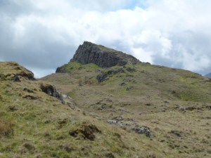
Onwards to Eskdale where we had our lunch by the side of the road. We then started up the Hardknott pass and came to a pub where an old chap waved us to stop. He needed a lift up the pass as his car had 2 blow outs and was in a passing place on the pass with his wife and one friend in it. He’d left another friend at the pub but wanted to take sandwiches and supplies up to the two women in the car who were waiting for the breakdown vehicle. We took him up to his car which was beyond where we were planning to park ours at Hardknott fort. So I did a 3 point turn on the Hardknott pass (Carol stayed relatively calm during this procedure) and took the car back to our park spot. For anyone who has not driven the Hardknott and/or Wrynose pass/es, it/they are not for the faint hearted. Many moments where you cannot actually see where to point the car because of the extreme drops. We then walked back up past our new pals and up to the top of the pass to find the “pile of stones”. Then we tackled Hardknott fell. Carol did this very well. I was slightly anxious as Wainwright had intimated that it had an indistinct ridge, that it was hard to get back down and made mention of a scree slope. Well it wasn’t and didn’t have any of those things. This is my 71st Wainwright so I’ve very nearly done one third of the 214. As we got back to the road, it started to rain heavily so we togged up. Back down the road, our pals had gone so I’m glad they were rescued, they were in the midst of clearing an elderly relation’s house and their 2 friends had come over for the weekend to give them some down time and then they’d had the breakdown so it had all been a bit tough for them.
Before heading for home, we had a quick look at the fort and trotted round the outside. Also looked at the bath house. This one has cold, medium and hot rooms plus a round sauna. Again, I decided not to as it was a bit nippy and we had to get back for our supper.
We went back to Eskdale Green and up over the moor passing where we had parked for Devoke Water. Managed to get back in good time for some non Roman showering. Steve and Linda provide complimentary sherry for guests so I had a very good dry one, lovely.
Then just down the road to the Wilson’s Arms in Torver. This was ok but Carol wasn’t really needing a huge meal and there wasn’t much she fancied. She ended up with a small portion of gammon with lots of grilled things but even so it still looked like an enormous portion. Thankfully it came at a smaller price. I had risotto balls. So yes risotto two nights running but I like risotto and these were very good. Beer was called Barngate Cracker. Ok but not as nice as that draught lager which I foolishly didn’t make a note of.
Aberlour from the honesty bar, such a fab idea, also a great little room with beaten copper topped tables. Still light at 10.50, wow!
From Hardknott looking eastWeather coming in fastOn top of Hardknott fellRavenglass Roman bath houseView to fells from Corney churchChurch at Corney
Roman sauna at Hardknott fortOn top of Hardknott fell, new hat. I lost the not very old one when out working.
Monday 22nd June
Carol enjoyed another large breakfast but I just had muesli with fresh fruit and yoghurt and a poached egg on toast. We packed up and headed off after a nice chat with Laurie, a fellow guest from Essex. Wheelgate is a great B&B and we are both hoping to go back there. They also have a single room in the main house plus a single in a separate building at the back.
We looked into the Deli attached to the Wilson’s Arms but it seemed to have reduced its stock since I last went in about a year ago so we didn’t linger. Into Coniston for a quick look round and then back home via the Windermere ferry. Back by 2.30 to get all the gear sorted and Carol on the machine.
On the ferryMining wagonOn Windermere looking southLooking north
Please visit Map and Compass and learn how to interpret a map and use a compass with me and my navigation partner, Cath.
Managed to start this walk at 10.00 a.m. Not as early as I’d hoped. I parked in Martindale which is a quiet little hamlet. There are some fun hairpin bends before you reach it. It has a new (1880) church dedicated to St. Peter and a much older one looking a bit sad dedicated to St. Martin (1500s).
I got up onto Place Fell quite quickly but then it took me a couple of hours to reach the summit. The fabulous views that Wainwright had promised were caught in the low clouds for most of the morning. Also an occasional sprinkle of rain to accompany them.
It was then down 250m to reach Boredale Hause which is a big mountain pass/col. From there I went up again for 150m to reach Angletarn Pikes. I ascended the north pike which Wainwright said could only be reached by a rock scramble. Not so, I just walked up a steep grassy bit and then was on a short easy path. Where Place Fell had seemed a bit busy (it was a bank holiday), I had the summit of Angletarn to myself. There are 2 pikes but I only climbed the north one.
I lunched in peace in the sun behind some rocks in a shallow depression. The rocks not me. Two cyclists came along but left me in peace.
Then it was time to head back along the ridge to Beda Head which is the top point of Beda Fell. It had cleared up weather wise and I got great views across to the huge long ridge which culminates in Hight Street to the east and to the west, Helvellyn and Sheffield Pike. I could trace the route Chris and I took for Sheffield Pike in November 2013. Also another horseshoe I did from Brothers Water.
I’m planning my own longish distance path along the route of the Roman Road between Penrith and Ravenglass. We’ll see! More realistically I could walk from Pooley Bridge up onto the far north end of High Street (not the summit end), taking in several summits but all along the very long ridge which is the Roman Road and ending up at High Street summit, this would be about 14 km. Then to get down to the Kirkstone Pass to meet a bus. Again, we’ll see, I would need to be in Pooley Bridge the night before for an early start.
After Beda Head, I turned east and down to get to the road and then a quick hop past the old church to get back to the car at 16.30. I saw a sign saying that Martindale is home to an old herd of red deer. Didn’t see any.
Managed to get home by 19.15 including a very quick pitstop at Tebay services.
St. Martin’s churchVery superior signpost!The walk to comeBrothers WaterHelvellynAngletarn Pikes (north pike)Sheffield PikeHigh Street in backgroundBeda FellUllswaterLooking back at Place Fell horseshoeUllswater
Please visit Map and Compass and learn how to interpret a map and use a compass with me and my navigation partner, Cath.