Yewbarrow and Red Pike, 4th May 2015

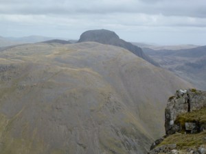
Pillar continues to elude me, in that I’m not yet ready for it, or at least I have to reconsider how to get to the west side of the Lake District, do big, long walks and get home. The answer is not to try to do it all in one day. I spent as long driving the car as I did up the hill.

So despite getting up at 6 a.m. I didn’t start walking until 10.35 from the National Trust car park at Overbeck on Wast Water. I’d stopped for a very express espresso at Lancaster services and once to send a text. As I put my boots on the lace broke but I had the emergency laces to hand (probably the most essential of the emergency kit). My original plan had been to walk the Mosedale horseshoe which is a very big walk and so I cut it back to climb Yewbarrow and then decide how much further to go. I chatted to a Dutch family in the car park. They had 2 small children and it was their first ever mountain.

The climb up Yewbarrow is quite stiff and quickly reaches scrambling territory. I had to think out my moves but at least with scrambling you get to cover a lot of height quite quickly. I met up with the Dutch family at the top of the gully and they had wisely (the children were only about 5 or 6) decided to retrace their steps. They seemed to have had quite an adventure. It took me 2 hours to get to the top of Yewbarrow. I then whizzed along the top ridge and scrambled down to Dore Head and stopped for lunch on the col.

I decided to climb Red Pike as it seemed a straightforward climb and would notch up another Wainwright. And it was and it did. On the descent there appeared to be a rescue taking place on the side of Great Gable, the Sea King helicopter spent a lot of time going back and forth and eventually went away without apparently having rescued anyone. A rescue did take place, see Wasdale MR for more info.

Back down the valley along a wet path on the western flank of Yewbarrow and down to the car. And then 3 hours and 20 minutes to get home.

Pillar still on the To Do list!

Apart from the first one, photos are in reverse order.

Yewbarrow looking very pointy
U shaped valley along Over Beck
And with Herdwicks
And with Herdwicks
Great Gable looking very mysterious
Pillar and companions in the background
Such poise
Such poise
Stirrup Crag on Yewbarrow's north end
Stirrup Crag on Yewbarrow’s north end
Dore Head col looking to Red Pike
Yewbarrow ridge to Stirrup Crag
Great Door (and so it is)
Wast Water
Wast Water


Please visit Map and Compass and learn how to interpret a map and use a compass with me and my navigation partner, Cath.

MAPandCOMPASS

Coledale round 6th July 2014

IMG_2195
Wally the MR bear on the top of Grisedale Pike
IMG_2199
A peek through to Crummock Water
IMG_2192
Peeking to Derwent Water
IMG_2200
From Hopegill Head looking back to Grisedale Pike
IMG_2204
From the top of Eel Crag/Crag Hill
IMG_2206
Towards Outerside and Barrow

Our village had the Tour de France coming through today so I managed to escape by driving to the motorway via Denshaw. I guess it only added 10 mins or so each way but it feels like a long way round. The village was pretty much blocked off.
I like cycling but I don’t like crowds so after 2 and a half hours I had parked in Braithwaite and was heading up to Grisedale Pike. Chris and I went up a couple of years ago and it was so windy we had to cling to the mountain and my map blew away.
Today there wasn’t any wind until I’d reached the summit.
Next was Hopegill Head for figit pie lunch although I saved a bit for after the next peak.
Down to Coledale Hause and back up again to Eel Crag or Crag Hill. The trig point has fallen over and I had a chat with a couple of railwaymen.
I ate the rest of my lunch, glad most of the climbing done.
Down to Sail where I walked for a while with a chap who collects Marilyns and trig points.
I should have walked up Outerside but decided to give it a miss as my knees were starting to hurt. Took some ibuprofen and this enabled me to get up Barrow and get back to Braithwaite and the car.
I drove home the way I went in case my little single track short cut had not been reopened.

Please visit Map and Compass and learn how to interpret a map with me and my navigation partner, Cath.

Lakes in April 2014

Tuesday 22nd April
I picked Chris up from Todmorden and we set off smartly, stopping at Lancaster services for supplies from M&S and coffees, Tebay services for more supplies, Penrith for diesel and Keswick for an anorak and a head torch for Chris to add to her collection. We ate our M&S salads in the car park. She had butternut squash and I had a beetroot and mint one, they were very tasty. 

We parked in Bowness Knot car park and then walked the 7 miles to Black Sail youth hostel which really does feel remote as that’s the only way to get there although the YHA does have a Land Rover which trundles up and down with duvet covers and bottles of beer. We were in a room on the left of the main room with 4 bunk beds in it. Chris very kindly took the top bunk as I was worried that if it was hot, the heat would rise which would probably melt me as I’m currently having thermostat problems. We made up our beds. There was one other occupant. We made our dinner of boiled mixed veg, rice and LWIF meatballs. C didn’t feel so well so I had some of hers too then yummy Simnel cake I had made.  We drank Jennings’ Cocker Hoop and Snecklifter. I liked the Cocker Hoop better. Early to bed.
Old YHA Land Rover at Black Sail
Ennerdale Water
Ennerdale Water
On the road to Black Sail
Wednesday 23rd April
C snored and I sneezed but the woman we shared with from Birmingham was very forgiving or at least too polite to say we had kept her awake. I haven’t really slept for 3 weeks since my internal thermostat decided to go on the blink and give me the experience of random hot sweats at any time. The only good thing is that they don’t last very long but I do long to sleep through an entire night without either sneezing or sweating.
We had breakfast of yoghurt jam and granola pots. We tidied up and set off for Pillar. It soon became clear that Chris really wasn’t going to be able to go very far uphill so we changed our plans and walked a little further towards the head of the valley and then back to Bowness Knot along the south side of the river. This was a lovely walk going through different types of woodland. On the way we had pork pies for our lunch. We had planned to walk up Pillar and across to Steeple and down to Ennerdale YH but the walk we did do was still very pretty with the river burbling away.
Back at the car we went for a drive round to Wasdale and stopped at the Wasdale Head Inn for a pot of tea and shared a piece of cake.
Then drove back across the moor road to Ennerdale Bridge and stopped at the Fox and Hounds for supper. C had Cumberland sausage and mash and veg and gravy and I had sea bass and chips and veg and homemade tartare sauce. Washed down with Jennings beer on tap. The food was ok but not totally top notch. My fish was overdone.
We then drove back to Ennerdale YH for the night. I had asked by email if we could park here for last night while we walked to Black Sail but got a reply that we couldn’t. I then found that the woman from Birmingham had done so and she hadn’t even been staying there, Ggrrr! When I get time I will write a letter. However this reminded me that they never replied when the man in charge of Bryn Gwynant broke the noise curfew he was supposed to be implementing by playing rock music so loud it woke me up. Anyway it was lovely to shower and drink Moretti beer.
I watched the manager reverse the brand new YHA Land Rover in the dark towards the gate posts. Probably best to learn how to do this in the daylight IMHO!! I think it was unscathed but looked a close shave.
Early morning at Black Sail
Chris at Black Sail
Chris at Black Sail
Head of the valley
Head of the valley
It was this big!
It was this big!
Mad woman on bridge
Mad woman on bridge
The heron
The heron
Ennerdale Water
Ennerdale Water
Wasdale in the gloom
Thursday 24th April
We had a leisurely yoghurt breakfast again and then set off to drive across the mountain Whinlatter Pass to Keswick’s west side. We parked up and walked up Catbells. Chris found this hard work but I’m very grateful to her that she stuck with it and helped me reach my 61st Wainwright.  After all her efforts, we went into Keswick and had some food in the Square Orange cafe. C had a ciabatta and I had 2 tapas, a sort of omelette and some fresh tomato on bruschetta. Very delicious and a nice relaxing cafe.
Then we drove home.
Please visit Map and Compass and learn how to interpret a map with me and my navigation partner, Cath.
Mountain Rescue bears Ted and Wally on Catbells
Towards Skiddaw from Catbells
Chris with Derwent Water after exertions on Catbells

Cross Fell 13th April 2014

There are 2 places called Kirkland within about 40 miles of each other, one is to the west of the M6 and one to the east. The one I was headed for is near Penrith. Unfortunately I didn’t check where I’d programmed my sat nav to take me and although I did know I was going just east of Penrith, somehow I was so absorbed in listening to Bag of Bones written and read by Stephen King that I barely noticed that I’d passed Penrith.

Once I’d actually arrived at Kirkland number 2, I was about 2 and a bit hours later than I’d intended to be so this had to mean cutting my walk time back a bit. The original idea was for a circular walk taking in Cross Fell and back to the hamlet. I parked near the church and made my way up the fell. Straight away there is a sign mentioning that the path is part of Pennine Journey, this is a reference to Alfred Wainwright’s book of the same name. AW made his journey at the end of August/beginning of September 1939. He makes scant reference to world events and that’s understandable given his surroundings. He takes off to walk a good chunk of the Pennines as far up as Hadrian’s Wall clad in what I would say sounds like inappropriate clothing and footwear. There are accounts of the hob nails coming up through the boots. He only has one handkerchief and is suffering from a cold [this reminds me of Victoria Wood sketch where the prospective medical student is being interviewed and is asked “what do you think Othello was suffering from?” to which she brightly answers “he might have been suffering from a cold”!] Despite the time of year, the weather is awful and he gets it all. The most annoying scene in the book is when AW turns up at a farmhouse where a flood has taken place. Instead of offering to help out, all AW does is demand cups of tea from a woman who clearly has enough on her plate already. This narration did not endear me to AW but his walk probably did inspire and helped to lead to the formation of the Pennine Way in the 1960s.

My walk was just a fragment of AW’s. The route up the flank of Cross Fell is mostly along the Corpse Road. I felt really sorry for the poor people and more likely the poor horses who would have had to carry coffins up this track, the track is good in a lot of places particularly as far as the old mine workings but where it disappears it goes into deep bog. I managed to keep out of this and navigated my way through it but it wasn’t very delightful.

Although Cross Fell is high at 893 metres, it never feels as if you are climbing up a mountain, there are no steep sections, everything rises gently. It took me 2 hours and 20 minutes to reach the top. The top is a very broad plateau and on a lovely day would give views to Scotland, all the Lake District and so on. On a not very lovely day, it was just very cold (still some snow lying about) and very windy. I saw 7 people on my travels, 2 pairs of geezers, and 3 fell runners.

At the top I wolfed down the remains of my lunch and decided to return the way I had come, this was my compromise due to the reduced amount of time at my disposal. The weather was coming in and I found I didn’t really like Cross Fell very much, it had felt like a battle to get up it and so all I wanted to do was to get down.

I got back to the car in a record 1 hour and 40 mins which was nearly half the time it had taken me to get up. Partly this was because there were lots of long grassy sections which were virtually rock free and gently sloping, this enabled me to run for as long as they lasted so although I’m not a fell runner by any means and doing this with big boots and rucksack was not ideal, it was great fun and very liberating. I’ve run 3 times a week for a year and it feels like it’s really paid off and I was impressed with my stamina. I managed to avoid the bog on the way back down by sticking more rigidly to the Corpse Road. So even though it’s not quite long enough to qualify as a QMD, I would still say this was one as it was challenging, involved some navigational techniques and I learnt some things about myself.

Please visit Map and Compass and learn how to interpret a map with me and my navigation partner, Cath.

This is Kirkland Fell
Cross Fell
Cross Fell
It's a standard, I love these, looking towards Scotland
It’s a standard, I love these, looking towards Scotland
Golf ball on Great Dun Fell

P1020740

Lakeland
Lakeland

Sheffield Pike, 10th November 2013

I got up really early, well same as a weekday and I should have been at Chris’ house at 7.30 but first I nearly went flying along the paving slabs because of ice and then there was so much ice on my car that I couldn’t get into it! I eventually got the passenger door open and then had to kick the driver side door open from the inside. Couldn’t get into the boot at all. This all took ages.

I picked Chris up and we set off after I’d drunk her delicious coffee, literally her cup of coffee that was part of her breakfast. We’d just turned out of her road when we saw a dying cat, so I stopped the car and we went over but it had died by then. A nice man came out and covered it up. He said its owners never let it out.

So after all this we were late getting going and then we had to stop for loo and coffee at Lancaster services plus a little visit to M&S Food and WH Smiths.

We arrived at Glenridding and got togged up and managed to leave the car park at 11.40, not quite the 10.15 in my head!!

I’d wanted to go up to Glenridding Dodd but from the track there was no obvious access to the access land and clear signs saying no path. Despite magnifying the map I couldn’t see how we could reach the access land so we abandoned that plan and instead decided to go for Sheffield Pike first.

We went along the path to the Youth Hostel to where there are a lot of old mine buildings which are now activity centre bunkhouses, and a sign referring to skiing but no sign of any ski slope, I’ve now found that the ski slope is at Raise and better accessed from that side I would have thought: http://en.wikipedia.org/wiki/Raise_%28Lake_District%29 However we did see snow on the top of Helvellyn as it came into view.

We then moved around the substantial mining area and pondered what had been mined, I suggested lead and copper and this page says it was lead and silver: http://www.mineexplorer.org.uk/greenside.htm although you have to read the lot to work that out.

Eventually the path beside Greenside flattens out to a sort of wide, sandy beach by the stream, another less beautiful relic of the mine. Then it was our bog walk because Chris and I can’t go out without one. We stopped for our lunch but although the sun was stunning with the white tops it was quite cold. Then to the top for fabulous views across and around for long distances.

To descend we went east. I took a bearing so as to avoid some cliff areas, this was wise and worked a treat, we snaked down to the wall and then decided to go right and along a path we could see to the road as this was shorter than left along the wall to a PROW and down to the road. As it turned out not necessarily quicker! We handrailed the wall until we could get onto the path. Some people were at this point going down from Glenridding Dodd which meant that there must be a way through the access land to get back to the car park but we decided to stick with our path that we’d selected and follow it down. As it got darker and darker the path got harder and wetter. My dear companion had aching legs and did not enjoy this section. Apart from being concerned for Chris, I’m afraid I did!

Onto the road, we put our headlights on, batteries dying in mine and flash function not working in Chris’. A short hop and back to the car.

An adventuresome day all in all, but QMD as well.

IMG_1807
Who’s that girl?
IMG_1810
Over to Striding Edge
IMG_1811
From the top of Sheffield Pike
IMG_1819
Ullswater
IMG_1820
Getting dark
IMG_1821
It was dark from where we were standing but camera said OK

IMG_1806

Please visit Map and Compass and learn how to interpret a map with me and my navigation partner, Cath.

css.php