Bannerdale Crags, Mungrisdale Common and Souther Fell, 26th July 2015

Today’s walk plan was to knock off some Wainwrights at the back of Blencathra.

I parked up in Mungrisdale on the road verge after an easy journey of 2.5 hours without stopping for coffee. Set off at 10 a.m. Pleasant and easy walk to the top of the crags along a wide path. It was dry but blowy at the top.

P1030980
From Bannerdale Crags looking back to Mungrisdale village and beyond
P1030976
Heading up to Bannerdale Crags

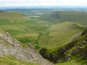
Down a little to a col which joins the Crags with a spur off Blencathra. At this point I veered off and headed due west to Mungrisdale Common. Wainwright must have been having a joke here, his description starts off with “To add to its other failings …..”, continues with “has no more pretension to elegance than a pudding that has been sat on” and “There is little on these extensive grass slopes to provide even a passing interest for an ordinary walker, and nothing at all to encourage a visit.” So why the bloody hell did he bother to put it in, it’s not even a summit as such. There is a suggestion that it was put in to provide some filler for the book on the Northern Fells. The common is a large, flat stretch of featureless bog. And very tedious because the bog got boggier and boggier as I went along, reminiscent of the bogs on the Isle of Jura. It started to rain so once I’d been and found the “summit”, I squelched my way back stopping for lunch on the way after I’d got off the bog. Not a soul in sight on the common.

P1030982
I’m on a road to nowhere
P1030981
A helpful navigational aid, just where it needed to be

Back at the col, I went down the River Glendaramackin to reach  a footbridge. Over this and then quickly up onto Souther Fell. The rain was coming in fast over Blencathra by this time. There was a path marked on the map which would take me directly to my car so I aimed off but crossed it without noticing (probably because too faint). So I headed back up a little (I’d overshot the distance) and then located the path in the bracken.

P1030994
Blencathra disappearing
P1030991
Why it’s called Sharp Edge
P1030992
Top of Glenderamackin River

This now brings my total of Wainwrights to 74 which is properly over one third of them done. Five and a half hours of walking. Home by 6 p.m.


Please visit Map and Compass and learn how to interpret a map and use a compass with me and my navigation partner, Cath.

MAPandCOMPASS

West Wales July 2015

Saturday 4th July

Chris and I waited for the clouds to blow away. We eventually drove off from Borth and got to Mwnt where it was at least not raining and the sun popped in every now and then. We’d had some falafel and hummous on the way to keep us going.

On arrival at the campsite, we tried to pay up but no-one was in so we got Chris’s tent up. It’s very spacious and well constructed by Vango. By then time was marching on so we went into Cardigan to the Grosvenor for chicken Caesar for me and Chris had fish with ratatouille. Both meals were very nice and we washed them down with Doom Bar beer.

After dinner, we drove up the coast a little and stopped to watch the sun go down along with some keen photographers who set up their tripods and did a lot of fiddling. This will be me one day.

Then it was back to the campsite and I set up my tarp and bivvy combo. Well now I’ve really looked at the pictures I can see I didn’t get this right at all. The idea with the tarp is that you use your walking poles as the poles (to reduce weight). This part went ok and I managed to stay dry all night as did my book and my shoes even though there was a lot of rain. But I didn’t get the tarp taut enough and it needed guy ropes. It didn’t come with guy ropes which is a serious error on the part of the manufacturer Rab as it ‘s not a cheap item so really they are being tight fisted here. All the photos of the Element Solo in action show it being used with guy ropes so I’ve got some on order now. The tarp acts as a flysheet and then I get myself and my sleeping bag and my mat into the bivvy bag which is a waterproof bag.

I drank rum and read some more of The Paying Guests by Sarah Waters, good book but it will end in tears, I haven’t yet finished it. It was amazing feeling all sleepy under the stars and seeing the moon through the end of the tarp. It was less good hearing a thumping base which it turned out was about 3 miles away.

P1030926
Sunset in Cardigan
IMG_0442
The mwnt at about 11pm
IMG_0441
Boat in the bay
IMG_0444
Chris in the enormous palatial tent

Sunday 5th July

I woke up early and went up the Mwnt to see the views, someone was making sand patterns on the beach. I also looked in the church which was peaceful. Got back to the campsite just in time to brew up and then the heavens opened again. We sat it out and then packed up the wet gear. First breakfast of fruit and granola in the car. We paid up which was when we found out about the distant noisy party.

We parked in the National Trust car park and visited the kiosk on the path to the beach, hot chocolate and freshly baked Welsh cakes for breakfast no. 2.

Just about missed the next downpour and then off to Llanerchaeron to make further good use of our National Trust memberships. Lunch first, Chris had a ploughman’s and I had a frittata. Yum yum!

We went round the walled gardens and met a nice cat. Then back to Borth where Chris made my supper of pasta and veg and sauce. Yum, yum yum!

IMG_0447
The tarp with bivvy bag
IMG_0453
Bring me my dinner!
Chris with a nice friendly pussy!
To the garden
To the garden
A water lily for Claude Monet (Carol in that hat)
Apple trees espaliered
Flowers for Chris
Flowers for Chris
Not sure I have the time to do this
The mwnt at Mwnt
The mwnt at Mwnt
On the beach
On the beach
Looking north from Mwnt
Our campsite
Our campsite
Cardigan island
Cardigan island
Sunset at Borth
Sunset at Borth


Please visit Map and Compass and learn how to interpret a map and use a compass with me and my navigation partner, Cath.

MAPandCOMPASS

css.php