Bowscale Tarn and Bowscale Fell 300411

Got up early and over to Tod by 8 to collect Chris. Left promptly, stopping at Lancaster services to stock up at M&S. A quick coffee and off to Mungisdale. Parked up, did huge amount of pfaffing and set off for the tarn. Quite windy but sunny and dry. Lunched on tuna nicoise, very nice, and watched a very foolish person going up the side of the tarn on a very difficult route where there isn’t really a path. They seemed to manage it though. We also watched a couple of other people take the route we were planning to do which looks much steeper from the bottom than when you are on it.
A little while later, we tackled it, it’s a short sharp way to the top and was fine except for being very windy which was a bit unnerving. However before long, we had reached the top and it was then a fairly short step up to the top of the fell. We came down on the other side which kept us out of the wind a bit and landed us right in the village next to the pub.
After a mix up with a cyclist taking Chris’ beer, we headed back along the road to the pub. On the way there was a national garden open so we popped in and had a lovely time, with me not knowing any plant names and Chris knowing quite a few. Mr had put various quirky sculptures round the garden so it was a bit like a treasure hunt. He clearly had an obsession about wood piles which was fine with me.
Finally got back to the car, drove round to the Bradley’s farm at Low Cock How and put up our tents in the garden on a nice flat bit of grass that wasn’t too dry so a bit springy.
Then we cooked up chicken green Thai curry and rice for dinner and ate this in the campers’ kitchen which suffered from an attack of hair, possibly dog or even horse.
A quick trip to the Shepherd’s Rest Hotel for beer, this turned out to be the wrong pub and we should really have gone to the Fox and Hounds as the Shepherds doesn’t review well. Our beer was fine. 
Totally knackered so back to the camp for tea with Chris’ special rum. 
We both did more sleeping than waking so perhaps not too bad a night really for camping.

At the tarn
Before the ascent
Bowscale Tarn
The tarn
Riding the wind

 Please visit Map and Compass and learn how to interpret a map with me and my navigation partner, Cath.

Save

Lakes March/April 2011

Saturday 26th March
Arrived in Longsleddale in the early afternoon. We are staying in the Coach House at Capplebarrow which is near the middle of the dale, just a few yards from the church and the village hall which are the only things in the dale apart from farms and houses. The River Sprint runs along the side of the single track road and we can see it from the Coach House. The Coach House is small and compact. There is the most enormous bed meaning we will have to send semaphore signals to each other. Very neat Morso wood burner that kicks out huge amount of heat, it compensates for the fan heater that only gives us 3 minutes in the shower room. After getting settled in we went for a short circuit along towards the head of the valley and then back along the far side of the river.
[googlemaps https://maps.google.com/maps?f=q&source=s_q&hl=en&geocode=&q=Longsleddale,+South+Lakeland+District,+United+Kingdom&aq=1&oq=longsleddale&sll=53.976128,-1.702121&sspn=0.015901,0.052314&t=p&ie=UTF8&hq=&hnear=Longsleddale,+Cumbria,+United+Kingdom&ll=54.440399,-2.790184&spn=0.029949,0.051498&z=13&iwloc=A&output=embed&w=300&h=300]

Sunday 27th March
Green Quarter
First day of forward clocks. We drove the first 3.5 km from our lodgings to Sadgill. Parked up. Lots of cars where before when I’ve been here there were none. Up a lovely stony track with burbling streams. Came across a vintage Land Rover mini rally. About 6 of them all trying to come down very steep bouldery part of path. Bloody bonkers but they seemed to be enjoying themselves. Seemed a risky thing to do to such beautifully preserved vehicles. Short stop where junction to Shipman Knotts and Kentmere Pike turns off.  Then away across the fell to Green Quarter. This is tiny hamlet next to Kentmere village. Out the other side and back onto the fell. Stopped for lunch looking over to Kentmere Tarn in the vale. On up to Green Quarter Fell. Passed Skeggles Water. This bit was quite bleak. Then on up Cocklaw Fell now overlooking our Longsleddale valley which is nice and green. On the homeward stretch with car in sight. Flapjack made by me v. good for keeping up energy levels as v. delicious.

[googlemaps https://maps.google.com/maps?f=q&source=s_q&hl=en&geocode=&q=Green+Quarter,+United+Kingdom&aq=2&oq=green+quarter&sll=54.424922,-2.784004&sspn=0.062916,0.209255&t=p&ie=UTF8&hq=&hnear=Kentmere,+Cumbria,+United+Kingdom&ll=54.430165,-2.840137&spn=0.014978,0.025749&z=14&iwloc=A&output=embed&w=300&h=300]

Monday 28th March

Harter Fell
It’s about an hour and a bit to drive a mere handful of miles because we are not crows. Parked up at Mardale Head. Free car park. Set off up Gatescarth Pass. After 20 mins I realised I’d left my iPhone on full view in the car. I left Mr B and raced down and back in 22 mins!   We plodded on and eventually arrived at the head of the pass. I also realised half way up that I’d left my lunch in the kitchen at the cottage. I considered pretending I’d only just found out when we sat to eat but instead fessed up feeling now very very stupid. Mr B kindly agreed to share his lunch with me and I gratefully accepted. We found a little hollow out of the wind and I ate half his lunch. After a bit more climbing we reached the summit of Harter Fell. Much colder on the tops. Headed off west to find the Nan Bield Pass. Some fairly challenging sections for Mr B height and exposure wise. It all went fine and we easily found the head of the pass. Mr B shared his Twix with me to give us a boost for the descent. It took a while but we got back down without further incident. Mr Bs first Wainwright and a jolly good one in perfect weather.


Towards High Street
Haweswater
On top of Harter Fell
Me too
Smallwater
Smallwater from the Nan Bield Pass
On the Nan Bield Pass


[googlemaps https://maps.google.com/maps?f=q&source=s_q&hl=en&geocode=&q=Harter+Fell,+Longsleddale,+South+Lakeland+District,+United+Kingdom&aq=0&oq=harter+fell&sll=54.430176,-2.840161&sspn=0.015727,0.052314&t=p&ie=UTF8&hq=&hnear=Harter+Fell&ll=54.476023,-2.834988&spn=0.029923,0.051498&z=13&iwloc=A&output=embed&w=300&h=300]

Tuesday 29th March

Not a very good day for walking so we went to Kendal and wandered round a lot, then went on to Sedbergh and looked at second hand bookshops
Kendal
Wednesday 30th March
Hugill Fell
This is an “outlying fell” according to Wainwright. Very wet so kept it short. Managed to stay dry with all the gear. Annoyingly it seems to be drier in afternoon which is not what forecast said. We didn’t bother looking at Williamson’s monument as it was too hard to get over wall plus high fence.
Wet
Very wet
Mafioso sheep
Thursday 31st March
It was so wet the Sprint had burst its banks in several places. Neither of us feeling like walking in the downpour so we went to Ambleside and Windermere for the day. It had finally brightened up in the evening enabling us to do a longer circuit in Longsleddale going further towards the head of the valley, looking up at Harter Fell.
The Coach House (the small building)
Cute now but may well turn into EVIL sheep
Longsleddale
Longsleddale
Longsleddale
Longsleddale church, sorry but this made me roar with laughing

Friday 1st April

More rain in the morning so we went to the Abbot Hall Gallery in Kendal which was good. Too early for the Sheila Fell exhibition though.
Eating Out

The Wheatsheaf at Brigsteer

The food was quite good but we had to wait oh so long for it I was nearly climbing the wall.
Both had braised beef, why this has to come in a little round I don’t know. Horseradish mash was good. Not enough gravy as meat a bit dry. Mushrooms and shallots tasty. Braised red cabbage so vinegary I coughed on every mouthful. But cauli and broccoli cheese yummy.
Deja Vue in Kendal
My meal was fine, I had celeriac for a starter and then a filo pastry and beetroot mille feuille. Mr B ordered tuna and it came and just was not right so he sent it back. He ate some chips and then we went home and he had a nice sandwich with ham. So a mixed bag, suspect it’s best not to bother with this one again.
Eating In
We cheated on the first evening and had pots of risotto which were fine and did the job.
I made Green Thai chicken curry with basmati rice. Fab!
Also an omelette with various bits and pieces, this was a bit dry as I had not quite got the measure of the electric cooker.
We had pasta bolognese twice, slightly different each time, but very nice.
Oh and I made more flapjack this time with apple and it didn’t really stick together so more like sticky granola. I will continue to experiment with the flapjack recipe as it’s so much nicer than buying an energy bar and a lot cheaper.
Please visit Map and Compass and learn how to interpret a map with me and my navigation partner, Cath.

Floutern Tarn 18-19 September

It really was this WET
Stir crazy

Carol and I set off early and arrived in Ennerdale after stopping for M&S treats and then to eat them. We both had sandwiches we’d made at home as well.
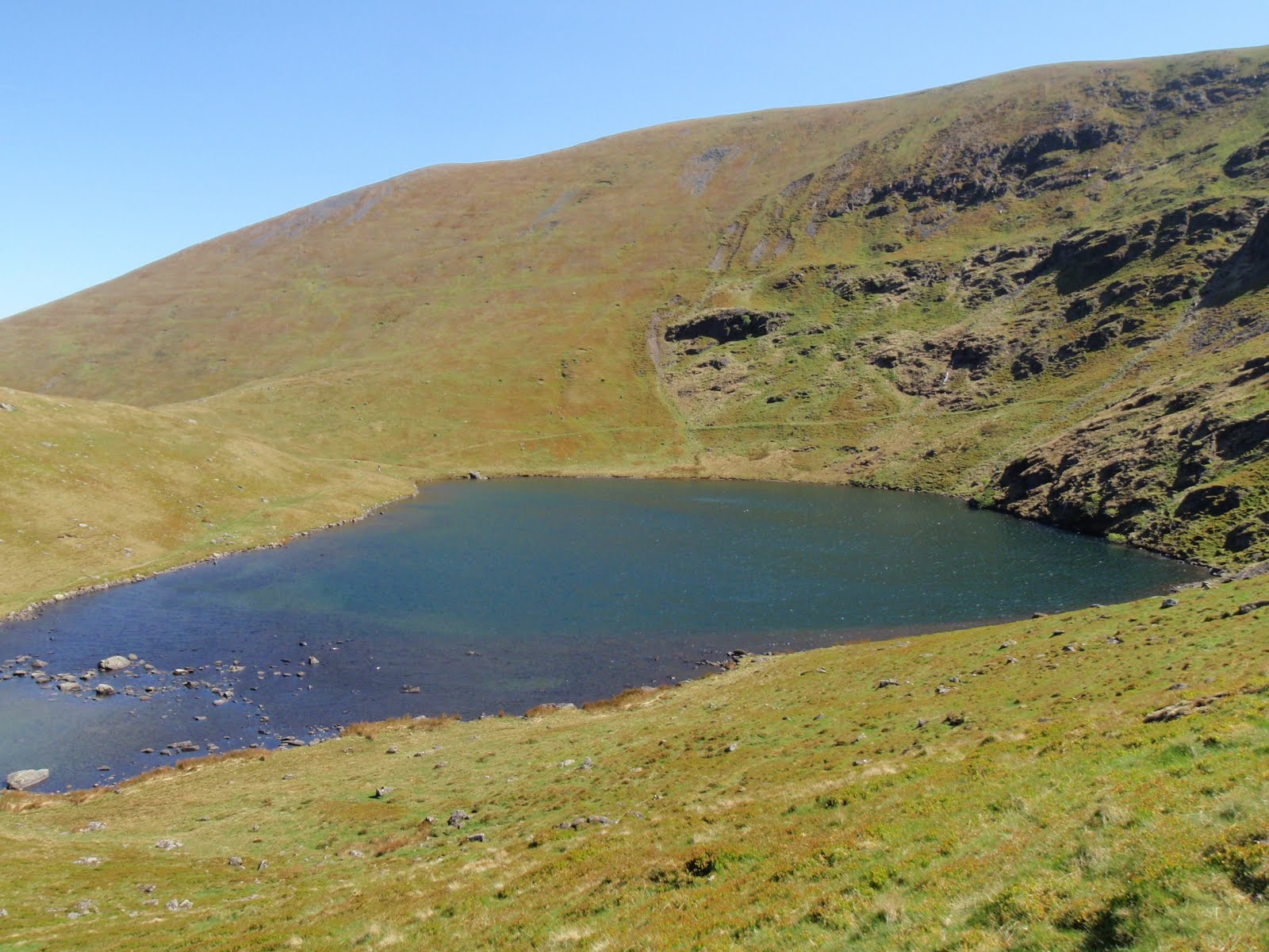
We parked the car and set off up the path to Floutern Tarn which we reached without event at 4.00 p.m. This time we found a flatter spot a bit higher up than previously. I quickly erected the tent and got the beds made up and then it started to rain. And then it continued to do so for the next 18 hours without cease.
At first it was ok because we had things to do, latrines to dig, organising our little space for maximum comfort and ease. We had a cup of tea and a little rest. We took some clothes off and then put a whole load more on as it went a bit nippy in the wind and the rain. It did not remind me of this song at the time: Drive All Night. Then it was time to cook the dinner. The tent has a good sized porch so we could cook without getting drenched. Starter of chick pea curry, followed by basmati rice and chilli con carne. C provided buttered brown bread. We finished it off with some chocolate. Then more hot drinks, whisky and sherry. We did a quiz, played some games, did the crossword. Hot food and drink make all the difference, whatever the weather.
We did of course have to leave the tent for the loo, yes in the dark and the rain, so misty I could barely see the walking pole marker post but mainly staying in a very confined space for such a long time is quite hard work. We did sleep but not brilliantly. The tent kept us warm and dry but you can’t really sit up in it very easily, it’s a good job we seemed to be not too bad at tentiquette. By morning I was going mad just to move my legs further than the tent door.
We woke at about 8.00 a.m. Some tea and coffee, and a rain check! Oh what a surprise still bloody raining and no sign of the tarn a mere 30m away.
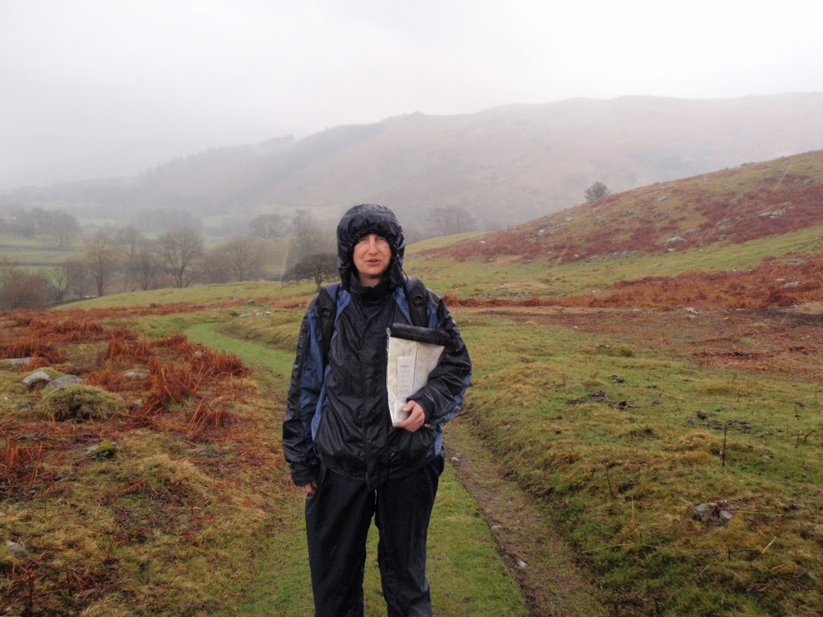
We packed up everything possible from within. Then stepped out in all our gear and stowed away the tent. Soon got warm by walking back up the hill. The path is pretty distinct which is a good thing as there was very limited visibility. It was really a great relief to be walking about.
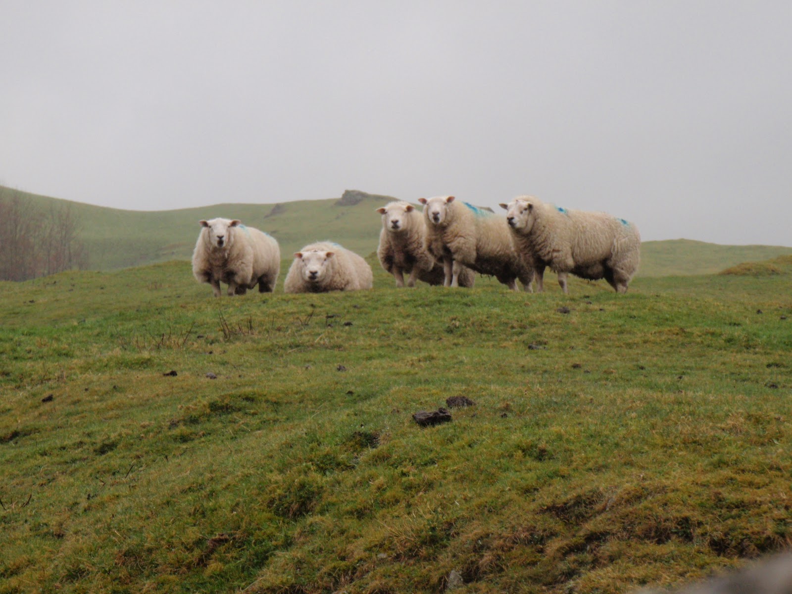
At the first gate you come to, we met a man and dog. We chatted and he told us that the farmer who owns the land including the tarn, has a penchant for waving his shotgun at “trespassers” – in inverted commas because the tarn is on Access Land i.e. we have a right to use it. This is the 3rd time I’ve camped there now, and I feel reluctant to go back. This farmer is known for his negative attitudes and the Ramblers have done Mass Trespasses on his land but to no avail.
We got back to the car and then guess what, it stopped raining! After a bit of pfaffing about, we got into the warm and dry and drove off to our next meal stop.
I felt I needed to get some pampering after 18 hours of rain, so we went to the hotel which said we could check in from 2.00 p.m. We arrived at half past and our room wasn’t ready so we had to wait for another half hour. After this annoying start, we got into the room which felt very hot. Turned all the radiators off, but this made no difference at all. So from one extreme to another. We opened all the windows but it just stayed hot. I even ended up sleeping outside the covers for most of the night, that’s how blooming tropical it was!
After all the rain we needed more water so had a shower/bath to clean up, went for a swim which was nice as the water was cool and then another shower/bath after the swim.
We pootled about a bit, read the paper etc. Got some ice in a bucket and dunked the wine in it.
Time for dinner, I had smoked salmon blinis and mushroom stroganoff. C had fillet of salmon and sticky toffee pudding. All very nicely done.
We returned to the sauna bedroom, drank all the wine and fell asleep.

Cloud carrying 18 hours of rain

[googlemaps https://maps.google.com/maps?f=q&source=s_q&hl=en&geocode=&q=Floutern+Tarn,+Loweswater,+Allerdale+District,+United+Kingdom&aq=0&oq=floutern+&sll=54.640267,-3.132133&sspn=0.062585,0.209255&t=p&ie=UTF8&hq=&hnear=Floutern+Tarn&ll=54.541003,-3.354177&spn=0.014938,0.025749&z=14&iwloc=A&output=embed&w=300&h=300]

Please visit Map and Compass and learn how to interpret a map with me and my navigation partner, Cath.

Skiddaw 290810

It was raining hard when I woke up, so anorak on and a smart walk to the “old loos, no queuing!” Back for breakfast of muesli and yoghurt, ok I very rarely eat anything else. Put all my clothes on as it was quite nippy and packed up the tent fast, by now it had stopped raining. I managed to strike camp in half an hour, considering that making camp takes me about 20 minutes, the main difference is that trying to squash things down requires me to lie full length and weight on them in a vain hope that they won’t pop up again the minute I let go. Oh this is starting to sound mucky…
I drove to the foot of Skiddaw to a free car park near Latrigg. The walk is a long old slog up a broad path that crosses grassy slopes. I’m starting to see what Wainwright meant about grassy slopes, they’re not that interesting in the scheme of things. There weren’t a lot of people around as it was still fairly early. I had believed the MWIS forecasts of -6 in the wind chill and whilst it was windy and chilly, I probably didn’t need all my layers to go uphill. AW mentioned that someone had “driven a motor car” up Skiddaw and for most of the way I could believe this, just one or two places where I would not have taken my car for sure, where it is less than a single track road in width and drops away steeply, also where tyres would be ripped to shreds by jagged rocks. (Blondie)
My feet were still very warm and I developed a blister so a short rest to apply Compeed. Then a final burst to get to the top, the views are magnificent and you really get the 360 degree feeling. It was bitterly cold in the wind so I stopped to join the only 2 other occupants of the wind break at midday, just over 2 hours to get there. One of these was a young teenager to whom I dispensed a further Compeed. Why can’t people learn to look after themselves, or perhaps his father could have taken some responsibility and carried a first aid kit? Rant over!
I quickly ate my lunch of bean tortilla. Suddenly the whole place seemed to be overrun with people, I don’t really know where they all came from! Time to move off. I set off for Skiddaw Little Man. The main track was now full of tourist walkers mostly looking like they wished they were doing anything else. Some were clearly very cold and suffering. Going up was a woman in a low slung wheelchair being hauled up by 6 men by rope and pushed up by 2 men. They looked like they could have done with chest and/or waist harnesses to do this job rather than just a loop of rope which would cut into whichever shoulder it was on.
I carried on up Little Man, AW recommends doing this on the way down so you don’t have to do so much climbing. Then it was down all the way and I was back at the car by 2.30. All in all I don’t think I’ll bother with Skiddaw again, the views are fab but it will always be windy and cold up there as there is no shelter from any land mass. There are plenty of other big fells that aren’t so full of day trippers too.

The zig zag path
Getting nearer
Bassenthwaite Lake
Skiddaw Little Man and Derwent Water
Funny little dog got in my photo

[googlemaps https://maps.google.com/maps?f=q&source=s_q&hl=en&geocode=&q=Skiddaw,+Underskiddaw,+Allerdale+District,+United+Kingdom&aq=2&oq=skiddaw&sll=54.517221,-3.148527&sspn=0.015694,0.052314&t=p&ie=UTF8&hq=Skiddaw,&hnear=Underskiddaw,+Cumbria,+United+Kingdom&ll=54.623376,-3.155479&spn=0.029815,0.051498&z=13&output=embed&w=300&h=300]

Please visit Map and Compass and learn how to interpret a map with me and my navigation partner, Cath.

Bleaberry Fell 280810

I’d prepped everything in advance with one of my packing lists so relaxed late departure from home. Stopped at Marks and Spencer, Lancaster which was heaving and bought an instant tuna salad lunch, and a 3 bean tortilla wrap for Sunday and 3 x 1.5 litre bottles of water, which despite packing list I had somehow managed to forget. Actually I was feeling a bit dozy and had even driven off down the wrong road in the village and had to turn back but at least that woke me up and told me I was not quite with it.
I found the turning to Burns’ Farm Camp Site very easily and it is just a mile off the A66. Linda was running around and decided she could fit me in but would have to charge me the full rate of £12 as I was only staying one night. As I had no idea what any other rate was this was fine. The field was very soggy and very full but I got a pitch that was flat if muddy. I put the tent up and made my bed, then ate my tuna lunch in the car.
I then drove down the back roads, didn’t stop at Castlerigg stone circle as it looked mega busy, and cut across the bottom end of Keswick to get onto the Borrowdale Road. Just a very short ride and I was at a National Trust car park on the left. Now that I’ve joined the Nat Trust, all my car parking in their parks is free, so far I have recouped nearly 1/3 of the membership fee by parking just 3 times. Well worth it just for this, as have only an occasional desire to be patronised by well meaning volunteers. OK, this is a bit harsh but I’ll definitely get the use by parking whereas I can’t guarantee to spend the year wandering around stately homos.
I walked up Cat Gill which was very pretty, it opens out above the woods and here I met a man with a Rhodesian Ridgeback dog. A very handsome beast and extremely well behaved. He was a nice man and told me his wife had died and he had got the dog for company. He was staying in a camper van at Castlerigg Hall camp site and had walked across. This is the camp site next to Castlerigg Farm camp site where I stayed last year.
I’m just relishing my flagrant use of Wikipedia links, which I have to spend all my time pooh poohing when I’m marking my students’ work, ha bloody ha!
Then I steered right across the bracken and crossed at the head of some falls, then over a stream and across to the head of Cat Gill. At this point, the map and the ground do not quite agree so I took a bearing and marched across the moor to meet the path. The path winds round a nice looking mound, then past a very well maintained sheep fold and bears left to ascend Bleaberry Fell. I mused as to what a bleaberry was but there was no berry of any description in sight.
I got to the top very quickly as the path is good, I wandered around a bit on the top to see how far the next fell was but decided not to try it as it was still threatening to rain a lot even though I managed to stay dry all through the walk.
I whizzed back down, this was a good warm up walk at around 500m of climbing. Drove back to the camp site, cooked up my dinner in the porch as it was starting to rain – bean and chorizo soup, pasta and tomato sauce. I washed up and then settled down in the tent. I was feeling a bit cold so got into my merino wool outfit and put all my other layers on and got into the sleeping bag. Before long, everything had to come off. Once I was comfy, I drank 2 cans of Greene King IPA and a miniature bottle of whisky whilst reading my book. Still on Daughters of Britannia, which I’ve been dipping into for ages.
My fellow campers were a bit noisy but everything stopped at 10.00, guess the rain helped here. I didn’t sleep very well, it was wet and windy all night.

Burns Farm camp site looking to Blencathra
Spooky bit in Cat Gill
Head of Cat Gill, not a cat to be seen either
Hole in my sky (I don’t even much like the Indigo Girls!)

[googlemaps https://maps.google.com/maps?f=q&source=s_q&hl=en&geocode=&q=Borrowdale,+United+Kingdom&aq=0&oq=borrowdale&sll=54.536671,-3.139687&sspn=0.031372,0.104628&t=p&ie=UTF8&hq=&hnear=Borrowdale,+Cumbria,+United+Kingdom&ll=54.517993,-3.148527&spn=0.014946,0.025749&z=14&iwloc=A&output=embed&w=300&h=300]

Please visit Map and Compass and learn how to interpret a map with me and my navigation partner, Cath.

css.php