Thursday 10th September Day 3

Both my heritages, left for pater, right for mater!
This is a rocket, right!
Cooee!

We did this earlier on, aaargh!


Having recovered from the ladder experience, this day was to present a different challenge. Before setting out all our bags were carefully inspected by Stephane, much got chucked out and packs were much lighter. I also chucked out my heel lifts and was instantly more comfortable and able to balance properly.

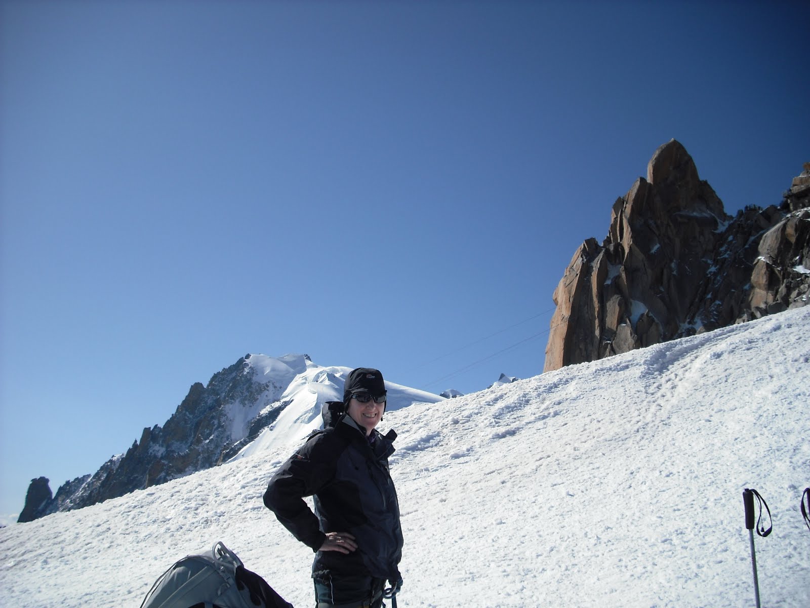
We set off on a big cable car up to the Aiguille du Midi. This station is at 3842m and you change cable cars half way up. The station has a rocket on top. Not a very good or beautiful rocket, more of a Thunderbirds type. We got out and cramponed up with axes at the ready.
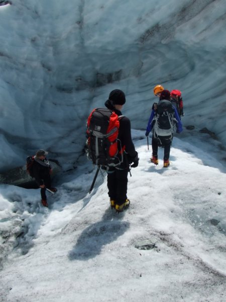
Straight away, the first thing we had to negotiate was an arete (ridge) of mind numbing terror. My mind did go numb and I just stopped. Being roped to Ann and Stephane, I guess this was not a very bright thing to do but I did nearly lose it. However, on looking ahead, the actual ridge was not very long. I had seen people coming up it when we got out of the cable car and had taken a photo, as you do, thinking “blimey, some people do mad things!” little dreaming that I was about to be one of them.
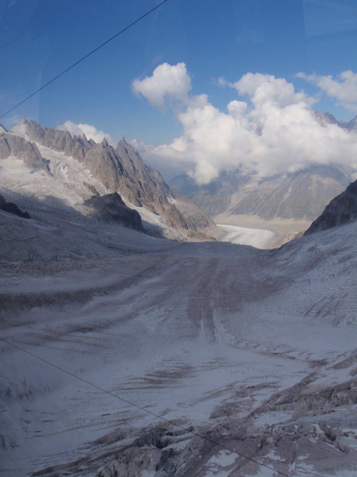
But once done, soon forgotten and then it was across the Vallee Blanche which was just as described. We crossed crevasses, wending our way for about 5km in lovely weather, and consolidating the skills, crampon wise of the day before. Whilst roped up I got a phone call from the manager at the residential home where my aunt lives, I’m not sure he believed me when I said I was crossing a crevasse! A short stop for lunch, so short I didn’t get any in my mouth and then a short walk to the Helbronner cable station. This station is on the border of France and Italy so I celebrated my dual heritages by spreading myself across the border whilst Ann took photos of me under the flag signs.
The return journey from Helbronner involved a very small cable car which I shared with Annie and Caroline. They started jigging about to Leona Lewis and Steps and it got a bit worrisome for me. Annie stopped when I mentioned my fears were similar to hers of being stuck in the big cable car with lots of people. Fantastic views of where we’d walked. Then all the way down from the Aiguille du Midi to Chamonix and refreshments in a cafe. Walked back to the hotel and evening meal followed by seriously sad and quite weird film about a creepy young guy and his girlfriend Lucille, who he clearly thought was not really human, and their attempt to climb Everest. The attempt resulted in both their deaths. She falling down a crevasse and him just dying hopelessly. The film was strangely edited and the subtitles stopped even before L went down the hole. Just what you want to watch before climbing your first very big mountain!

[googlemaps https://maps.google.com/maps?f=q&source=s_q&hl=en&geocode=&q=helbronner+chamonix&aq=&sll=45.922329,6.874545&sspn=0.018808,0.052314&ie=UTF8&hq=&hnear=Pointe+Helbronner&t=m&ll=45.845722,6.931944&spn=0.017937,0.025749&z=14&iwloc=A&output=embed&w=300&h=300]

Please visit Map and Compass and learn how to interpret a map with me and my navigation partner, Cath.

Wednesday 9th September Day 2

Mer de Glace

Lots of continental breakfast to sustain us for the day ahead. Into town in Mario’s minibus to a little station to take a little train to Montenvers railway station which gives access to the Mer de Glace. We set off walking in our full winter gear (well I did), plus ice axes, helmets and crampons. After a short walk we came to a sheer cliff face which we descended via about 7 or 8 long ladders. My estimate was that the distance covered by the ladders was about 100m. When I read an article from the Independent (22/08/09) which has a photo of the ladders, the writer reckoned it was 200m. Go to More Photos and scroll through to see the wretched ladders! For me, going down, I quite enjoyed the ladders, it was only later on that I felt differently about them.

A few boulders and then straight onto the glacier. My only previous experience of a glacier was the Jostedal in Norway, which Chris and I just walked on very briefly in our ordinary shoes before a stampede of Japanese tourists arrived. I hope that is the right one!
Getting used to the crampons by tackling shallow slopes and then steeper ones. I do like crampons and feel very secure in them, I had really enjoyed the weekend in the Cairngorms with Chris Conley and Chris H learning to use them.
We moved onto some rope work – this means climbing up a slope using crampons and axe whilst attached to the rope which was attached to a fixed point. Again, this was made gradually steeper until finally we climbed a vertical wall of ice. I just about managed to do this, although did not make a very pretty picture! However the abseiling down was just fab, loved it!
We walked around and into sections of the glacier, wonderful ice formations.
Eventually it was time to return to ascend the cliff. I was very hot, and my pack was full, I also was having a problem balancing as my heel lifts had slipped to the middle of my boots so was pretty much totally out of kilter. Getting up those wretched ladders became a major challenge and there seemed to be many more of them than there had been going down. Both Pierrot and Stephane said my pack was too heavy.
We went back down on the little train and got picked up by Mario after a refreshment stop! A bit later we had our evening meal and then a bit of an old 50s climbing film where men wore corduroys but still dangled upside down from terribly high places.

Going down into the glacier
Ice climbing
Ice climbing
Alpinism oh yes!
Alpinism oh yes!


[googlemaps https://maps.google.com/maps?f=q&source=s_q&hl=en&geocode=&q=Montenvers+Mer+de+Glace,+Chamonix-Mont-Blanc,+France&aq=1&oq=montenvers&sll=45.923697,6.869433&sspn=0.300913,0.837021&ie=UTF8&hq=&hnear=Montenvers+Mer+de+Glace,+74400+Chamonix,+Haute-Savoie,+Rhone-Alpes,+France&t=m&ll=45.922737,6.875381&spn=0.017912,0.025749&z=14&iwloc=A&output=embed&w=300&h=300]

Please visit Map and Compass and learn how to interpret a map with me and my navigation partner, Cath.

And finally …. Mont Blanc

Big mountain from hotel window

Tuesday 8th September Day 1

Somewhat frustrating pre-flight irritations after being ready for days in advance! First of all a traffic jam at Yeadon, then my pre-paid car park entry wouldn’t let me in and lastly had to pay extra for my luggage. And all of this meant I missed my airport coffee!
Met up with Ann and we had a smooth, easy flight. Jet2, being budget, make you pay for refreshments so I was glad of my home made sandwich.
On arrival in Geneva, we were met by Mel plus Annie and Caroline. Straight off to Chamonix with me navigating Mel out of the airport and onto the right motorway, fairly straightforward, just followed the signs to France!
After an hour or so, we got to our hotel, La Chaumiere and met up with Liz who had been out for a run. Warming up for the big one! Lovely to see her (and Mel of course!) again.
Ann and I got a nice room with a balcony looking straight up at Mont Blanc. I whizzed into the town and bought a couple of pairs of cheap but warm trousers as had managed not to bring the right ones, grrr! I brought quite a lot of things I didn’t need at all but the trousers were the only thing I really missed. Still the $5 (keyboard needs a Euro symbol) ones did very well and now I’ve repaired them, I’ve passed them on!
On returning to the hotel, we met the guides for the trip, Pierrot Fiorucci who works in the Mercantour with Mel and Liz, and Stephane Benoist, who hails from Nice, and about whom, more later.
We ate a 3 course dinner which was very good.

[googlemaps https://maps.google.com/maps?f=q&source=s_q&hl=en&geocode=&q=Chamonix,+France&aq=0&oq=chamonix&sll=54.527028,-3.017583&sspn=0.06276,0.209255&ie=UTF8&hq=&hnear=Chamonix,+Haute-Savoie,+Rhone-Alpes,+France&t=m&ll=45.923931,6.869202&spn=0.143292,0.205994&z=11&iwloc=A&output=embed&w=300&h=300]

Please visit Map and Compass and learn how to interpret a map with me and my navigation partner, Cath.

Helvellyn 060909

Wythburn church


Left nice and early so managed to get to Wythburn car park at 10.00. The car park would have cost me £5 but the ticket machine was “Not in use”. Great.

A group of Polish (I think) people were smoking in the car park and set off before me. A short time later I overtook them, to say they were inappropriately dressed just doesn’t cover it, ready to go clubbing more like it!
Lovely walk through pine woods, rising steeply onto the fell with a few craggy bits and water chasing down. I’m starting to see what Wainwright means, it’s more interesting in terms of variety of landscape.
Fairly got up quickly. Had a chat with a bloke on the way and even patted his dog. Turned right at the junction and whizzed up to Nethermost Pike. Windy and some hard drizzle on the tops. Short whizz up to Helvellyn having looked across at large quantities of mad people doing Striding Edge despite the great wind and cold. I was told it was only 5 degrees on the top, but in my new Paramo I didn’t feel cold at all.
There was a tent on the summit which may have been connected with a triathlon (swim, “run” [not when I saw them!], bike). Also saw another tent down by the tarn and another one on my way down.N
Quick look round the top, had my sandwich in the rather grim shelter, sharing it with a couple and 2 small dogs with coats on. Wretched dogs far too close to my sandwich for comfort so had to eat it fast. I did feel cold in the windiest section of the shelter so didn’t hang about. Then more whizzing back down. A little rain on the way down but got down very quickly.
I never saw the Poles again so think they must have given up quite early on.
Great to have a walk with actual views for a change and not loads of rain.

[googlemaps https://maps.google.com/maps?f=q&source=s_q&hl=en&geocode=&q=helvellyn&aq=&sll=54.541601,-2.988281&sspn=0.125474,0.41851&ie=UTF8&hq=&hnear=Helvellyn&t=m&ll=54.527059,-3.017635&spn=0.029885,0.051498&z=13&iwloc=A&output=embed&w=300&h=300]

Please visit Map and Compass and learn how to interpret a map with me and my navigation partner, Cath.

Some Dodds 300809

Where the old YH sign used to be
Castlerigg Stone Circle


Started off from home a bit later than usual as would have more time later in the day. Getting through the Windermere, Ambleside, Grasmere bottle neck was immense fun and made the journey seem never ending.

My original plan had been to pitch tent and then walk but it was so late I parked at Legburthwaite car park and got walking.

Up to Sticks Pass having lunch on the way with my back to the wind and rain and then left this time to reach Stybarrow Dodd. The tops were in total mist although it did clear enough for me to get an idea of what was where. The now properly waterproofed jacket did the job fine this time, as did the new waterproof gloves. Went across to Watson’s Dodd and then returned by the same route.
Got down in almost half the time it took to get up, despite the wet and grassy slopes. Wainwright hated grassy slopes. During his account of his walk up the Pennines during the outbreak of WW2, almost 70 years ago to the day, he describes his footwear in detail and it was not up to the job so I reckon he skidded around too much on the grass and didn’t like it. In that book, he comes over as a very selfish and grubby man. No change of clothes for his weeks of walking and only one handkerchief! My favourite episode is where he arrives at a farm which has been flooded and Mrs Farmer is busy trying to deal with a flood. Instead of pitching in or offering to help, he demands tea from her!
As well as some more physical fitness, all this solo walking is also giving me more mental stamina and confidence which is great. So some good has come out of the apparent lunacy!
Back to the car, passing the old Thirlmere youth hostel at Stanah, now a very sorry sight, neglected and left to rot. The YHA shut it in 2001.
Decided to go to Castlerigg Farm Campsite as opposed to Castlerigg Hall Campsite. These are literally next door to each other but the Hall has lots of facilities and the Farm has fewer and is cheaper plus it has a “no noise after 10.30” policy.
I put the tent up very quickly, the dry run in the sitting room proved useful. It actually stopped raining whilst I did this which was nice, although not strictly necessary as the tent pitches with the fly attached, fab.
Got settled in and cooked my supper, pasta with stir in sauce, excellent. I was so hungry. Pocket Rocket worked like a dream, heated water fast. Pots also efficient as well as light.
Got warmed up with Paramo gilet and got into sleeping bag. Also warm and comfy. Dark early so read my book and tried to sleep but foam sleeping mat just not enough for my bones. Then it rained and rained and blew and blew so finally dozed off sometime around 3.00. Woke at 7.00, very groggy.
Brewed up coffee and had breakfast. Now so wet that decided to cancel walk to Helvellyn. Felt a bit crap about giving up walk, that had been purpose of camping trip but rain was extreme.
Struck camp, throwing all wet stuff, i.e. nearly everything, straight into the boot. The tent had kept me warm and dry and did very well for its first outing. A good test for future wild camps. All gear had worked well.
Went to Castlerigg stone circle and wandered round it in the rain. Then went and took some photos of the youth hostel at Stanah. Into Keswick to wander round all the gear shops for an hour.
Set off for home. Yet another crawl most of the way. Bit disappointed but the mountain will still be there next week.

[googlemaps https://maps.google.com/maps?f=q&source=s_q&hl=en&geocode=&q=watsons+dodd&aq=&sll=54.534087,-2.970821&sspn=0.125498,0.41851&ie=UTF8&hq=watsons+dodd&hnear=&t=m&ll=54.534231,-2.971115&spn=0.119521,0.205994&z=11&iwloc=A&output=embed&w=300&h=300]

Please visit Map and Compass and learn how to interpret a map with me and my navigation partner, Cath.

css.php