Wycoller mists 18th May 2013

Cath and I both used our sat navs to get to Wycoller and had managed to end up in different car parks! My route went through Hebden across Keighley Moor to Oxenhope and then across to Wycoller past a couple of big reservoirs but most of the journey was in such low cloud that I didn’t see anything. I strolled down to the Visitor Centre and we decided to set off after a hot drink. We went to the cafe where I thought I’d seen Celia Imrie several years ago. We both had huge pieces of freshly baked and very good Bakewell tart. Yes it was. Our plan was to spec out one of Cath’s advanced walks for the book she is writing and to agree an outline for how we would teach navigation skills on a day walk.

We set off from Wycoller, passing the ruined hall, my last trip there had been to see the Midsommer Actors doing The Hound of the Baskervilles as a walkabout, very atmospheric location for the play. Wycoller is also where Chris saw a ghost on the bridge, not sure which one, I don’t think the ghost was any of those listed here.

The first part of our walk was very pleasant along leafy lanes, past fields with lambs and calves. Once we crossed the road onto the access land the cloud was on top of us and we could not see far at all. The idea with this walk was that people would have some handrails to use but would then go off piste for the advanced skills part. We came across the first hiccup when we had to climb a wooden fence. Whilst we felt ok about doing this as we were on access land, we didn’t think it would be ok to encourage walkers to do this in a book and we weren’t sure of the legalities of it or how one would get permission. We carried on over the clumps and bumps and bog, it didn’t rain much but everything felt damp because of being in the cloud. We practised a bit of timing, a bit of pacing, did a bit of walking on a bearing. We remembered to trust our tools and worked out that we had not gone far enough to reach our objective which was a footpath crossing the bog. Sadly this was a path that existed only in the cartographer’s mind and not in reality. Cath went off to see if she could find it and started to disappear so I went after her. We actually ended up where the path should be according to my GPS. So this was a mixture of using our maps and compasses plus the GPS for backup. I put the backup away as it had confirmed that we were where we thought we ought to be. As the terrain was hard going, we decided to head back to the road, stopping for a quick bite to eat in the bog as it was late for lunch by then.

We saw a couple of geese and a couple of grouse, well they were minding their own business and probably thought we were quite mad to be tramping about in the mist.

We got back to the road by walking on a bearing, again good practice as we both had the feeling that the direction was other than that indicated by our compasses, but because we trusted our tools we got to where we wanted to be. It really would have been very easy to walk round and round in circles without a compass in those conditions.

Cath had already decided that the moor we’d been on wasn’t a suitable addition for her book by this point as it had been a bit of a bog slog.

We thought we would take a footpath back to my car park and get off the road which was misty, narrow and a bit busy so we took a sign leading out of a disused pub’s car park and across a field with sheep in it. The path clearly went across a field boundary on the map but in reality this was a tall stone wall with a lot of barbed wire, we tried to get over but it was a bit too hard so we went back to the road and climbed over a fence with barbed wire to get out of the field, managing to make some holes in Cath’s map in the process.

Back along the road to the car and then down to the cafe for making notes and plans. This time we skipped the cakes!

I’m just glad that I was with Cath for all these adventures. I will be writing to Lancashire Council about the blocked footpath.
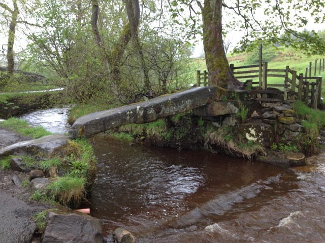
Fab single stone clapper bridge at Wycoller
Distinctive lichen
Distinctive lichen
Footbridge at Wycoller
Wycoller clapper bridge
Fireplace Wycoller Hall

Please visit Map and Compass and learn how to interpret a map with me and my navigation partner, Cath.

Thieveley Pike 12th May 2013

This walk is in my new book Great Mountain Days in the Pennines. I like the title as I don’t really think of our local hills as mountains. More rain was forecast so I cut it back a bit before starting from the layby near Holme Chapel. I walked along the road a bit and passed an old ruined house called The Holme and then decided to do a short cut along a right of way with footpath across the fields. At the end of the field there was a very big timber operation going on with several tractors and saws. They seemed to be cutting up a huge tree of about a metre and a half in diameter. Although the official footpath went right through this lot, I sensibly decided to aim straight for the open gateway so as not to get in their way.

A hi viz man came towards me and suggested that as I was heading to the gate he would “let me off” for straying from the footpath. I said I was trying not to interfere with their wood cutting operations. What a bloody jobsworth. It was far more sensible to keep right away from the vehicles and chainsaws than to stick rigidly to the path and I had made a considered decision. I knew I wasn’t on access land and I knew where the path went but this seemed to be picky for no good reason.

Holme Hall, Holme Chapel
Dean Scout
Dean Scout
Rocks on Dean Scout
Rocks on Dean Scout

So thoroughly disgruntled, I headed on up through Buckley Wood and Thieveley Wood. When I got to an open spot to eat my lunch, the rain really came on. I plodded on up to the top of Thieveley Pike. This is on access land and you can get to the beacon which is a little way from the trig point but it was so wet and cold and windy that I decided to cut short my walk and return back the same way to my lunch spot and then take a different tack to avoid the wood cutters. I went through Fish Pond Plantation and down to the fish pond itself, only passed one man who was chopping bits of wood in the plantation. Very quickly back at the car.

Please visit Map and Compass and learn how to interpret a map with me and my navigation partner, Cath.

Gorple circuit May 6th 2013

Carol and I did a very similar route to one I did not long ago with Cath, except we made it a bit shorter today.

We walked on bits of the Pennine Way and the Pennine Bridleway, sometimes both at the same time. It was a lovely sunny day and I had to put the factor 50 on for the first time this year.

Started at the car park for the Walshaw Dean reservoirs, dropped down to Graining Water, crossed the 2 footbridges and then up to Gorple Cottages, then to Reap’s Cross still marked as “rems of” on the map but actually “restored by the people of this hillside” a few years ago.

That was the end of the good paths, from the cross it’s a hike across the very dry moor. All the bogs have dried up. We listened to curlews and peewits and wrens and managed to make a goose very cross. Then we came upon another pair of geese so we did a bit of a detour so as not to upset them too. This took us to Raistrick Greave which is a large ruin.

From there to the old scout hut. At this point we stopped for Carol to have her lunch, half of mine had gone at Reap’s Cross and half at Raistrick Greave. Whilst there I investigated a second footbridge and some steps leading up to a good path, none of which are marked on the map. It looks like they give access to a set of grouse butts.

From the scout hut we started back taking in Gorple Lower reservoir. A lovely day out in the sun.

Gorple Lower reservoir
Graining Water
Graining Water
From Raistrick Greave
Blackbird for Carol
Blackbird for Carol

P1010849 P1010853 P1010863 P1010866

 Please visit Map and Compass and learn how to interpret a map with me and my navigation partner, Cath.

Pennine Bridleway May 5th 2013

IMG_1294 IMG_1290 IMG_1291 IMG_1292 IMG_1293Chris and I did about 20k from her house. I only started measuring the distance when we’d already gone quite a way.
We went up to Mankinholes on the road and then along the bridleway which at that part is called London Road, decided not to go all the way to London today. It’s been refurbished and is now quite good to cycle on, less boggy but actually everywhere is very dry. We just followed the PB (blue markers) along packhorse roads and then dropped down to Callis Wood. Stopped for a late lunch by the river and then down through the wood to the canal. We took the canal back to Tod as far as Woodhouse Road, watched some men getting a barge through a lock. We had to carry the bikes up some extremely steep steps to get onto Woodhouse Road, they would be hard without a bike. Then up and up what used to be a lovely pretty lane and is now foully marred by the dumping of detritus. Up some more to the Shepherd’s Rest. Then down all the way back to Chris’ house for a welcome cup of tea.
I managed to get oil all over my clothes trying to get the bike back up on the car which was a struggle because it was at a bit of an angle. Then when I got home found I had a four inch scratch down my calf. No idea where that came from.
We were celebrating Karl Marx’ birthday: http://imperialsenate.wordpress.com/tag/karl-marx/

Please visit Map and Compass and learn how to interpret a map with me and my navigation partner, Cath.

Water board ways 4th May 2013

I did a quick walk from Spa Clough reservoir near Junction 22 of the M62. I’ve seen what looks like a good track every time I’ve driven home from J22 and now I’ve finally got to walk it. To be honest it’s not very exciting. There are various water board things to control the water and lots of inlets but that’s about it. The M62 is very near although mostly I hardly noticed it apart from when it was in actual sight. It was sunny and windy.

Booth Wood reservoir

IMG_1280 IMG_1282 IMG_1285 IMG_1289Please visit Map and Compass and learn how to interpret a map with me and my navigation partner, Cath.

css.php